


Flood information for the Warrnambool City Council, encompassing local flood guides and a Municipal Flood Emergency Plan.
Warrnambool City Council Flood History
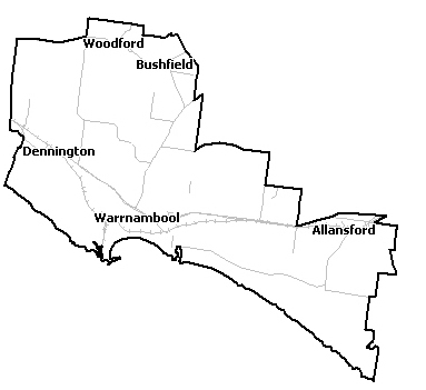
The Warrnambool area is at risk of flooding as a result of its location between the Merri and Hopkins River catchments coupled with estuary and tidal impacts.
The largest flood on record is the 1946 flood; which peaked at 8.55m against the local gauge height. The most recent floods in 2001 saw flood waters surge to 7.75m against the local gauge height.
Flooding in the Warrnambool area is heavily impacted by storm surges. For example the 1946 floods saw a 1 metre storm surge adding to the riverine flooding.
Warrnambool Local Flood Guide
About Flood Guides
Communities can use local flood guides to identify and better understand their local flood risk. They include information about: flood history, how to prepare & respond to floods and who to contact.
Contact Information


Local SES Units
- Warrnambool VICSES Unit:
40 Walsh Road,
Warrnambool.
Municipal Flood and Storm Plan
Municipalities can use Municipal Flood and Storm Plans to prepare, respond and recover from flood and storm events. Warnambool City Council Flood Emergency Plan - Updated July 2022 Shire Council Munsic Emergency Plan - Updated Dec, 2020